|
ABOUT SIERRA LEONE
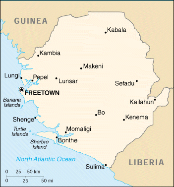
Sierra Leone is situated on the West Coast of Africa, latitudes 7° and 10° North and longitudes 10.50° and 13° West. It is bounded on the North and North East by the Republic of Guinea, on the east and southeast by Liberia and on the West and South by the Atlantic Ocean with a coastline stretching some 300 miles extending from the boundary with the Republic of Guinea to the north of the mouth of the Great Scarcies river on to southeast at the mouth of Mano river. From an approximately 70 mile-wide coastal belt of low-lying land the country rises to a mountain plateau near the eastern frontier, to a height of some 4,000 to 6,000 feet in the rich timber forest region. The western area consists of the Sierra Leone Peninsula, the small islands of Sherbro, Tasso, Plantain, Banana, Turtle, York and others, as well as areas of inland territory approximately 255 square miles in all. The country has a total land area of some 27,925 square miles (73,326 sq km),with a population of four million people. Freetown, the capital and main commercial centre, has the highest density per sq km, and roughly about a quarter of the inhabitants of the western area are Krios. The Peninsula on which Freetown stands is 25 miles long and 10 miles wide. A mountainous promontory, it rises in places to 300 feet above sea level, and is one of the few parts on the West African Coast where there is such high land so near the sea. This area has one of the world's best white sandy beaches, azure seas, pulsating resorts where the lush green forest spills down the hillsides to meet the most beautiful and unspoilt beaches. Sierra Leone is a tropical country with temperatures averaging 80°F (26°C). There are two seasons; the Dry Season, from November to April, has the best holiday weather; and the Wet or Rainy Season is from May to October. Population of 4,726,000 (1995). Also includes several thousand Lebanese, Indians, Pakistanis, and refugees from Liberia. Literacy rate 15%; blind population 28,000 (1982 WCE); deaf institutions 5. The main religions are Muslim, Christian, and Traditional. The official and commercial language of the country is English. Each of the 15 main ethnic groups has its own ethnic language, with the Temnes and Mendes comprising two-thirds of the population. However, an important vehicle of communication is Krio, the 'Lingua Franca', which is widely spoken within the country. Agriculture is the backbone of the nation's economy. About 80 per cent of the country's manpower is engaged in agricultural activities. The social organisation of agriculture is still based on land tenure. The land is communally owned by the tribe, but legal ownership is vested in the Chief on trust for the whole tribe. This practice is predominant in the rural areas. Land can also be inherited in some tribal communities which cannot be sold or bought by non-members. However, land tenure does not apply to the Western Area where the West European system of land tenure applies. Diamonds and other minerals still form a substantial portion of the country's export earnings. The main diamond and gold mining areas are in the Eastern Province: Tongo Field in the Kenema District, Yengema, Njaima Sewafe, Njaima Nimikoro, Tumbudu, Sefadu, and Koidu in the Kono District. There is alluvial mining also in the South. Gold mining also takes place in the Tonkolili and Koinadugu Districts in the Northem Province. Visitors are advised that it is illegal to buy or smuggle diamonds or gold out of the country without the necessary licences. Other important products that are also traded for export are timber, gold, bauxite, rutile, iron ore, coffee and ginger. Industrialisation is making steady progress, although it has been hampered in recent times by a rebel war. This pace will be considerably accelerated when the hydroelectric project at Bumbuna is complete The history of the country's poetic name 'Sierra Leone' dates back to 1462, when a Portuguese explorer, Pedro da Cintra, sailed down the coast of West Africa and saw the long range of mountains of what is now the Freetown Peninsula. As a result of the topographic configuration and climatic conditions experienced by the explorer at the time, he called the lands 'Sierra Lyoa' meaning 'Lion Mountains'. In the sixteenth century an English sailor called it 'Sierra Leoa'; by the seventeenth it was 'Sierra Leona', and by 1787, under the Sierra Leone Company, it became the first of several British Administrations. Through the years of British Colonisation, the original name was modified and it became 'Sierra Leone', the name by which the country is known today. Before being discovered by Europeans, the original local name for what is now 'Freetown' was 'Romarong', meaning the place of the 'Wailers'; so-called because of the constant weeping and screaming of victims of storm and cross-current disasters at the mouth of the Sierra Leone river. (Interestingly, when the Portuguese sailor, Pedro da Cintra called the country by its present name 'Sierra Lyoa', he had not deviated much from the concept of the indigenous people of names based on the observation of nature. During the latter half of the 18th Century, Bunce Island was one of the major slave trading operations on the Rice Coast of West Africa. Sierra Leone was for many years used as a slave trading outpost until it was gradually phased out and later, in the 18th century, it became a settlement for freed slaves after the English philanthropist Granville Sharpe, who was deeply concerned about the welfare of freed slaves, published his proposal to take them all back to Africa and settle them there where they could prosper in a genial climate. Much has been written of the traumatic history of the Slave Trade, but one of the most courageous stories of the fight of Sierra Leoneans against slavery is the story of the Amistad. Part of the legacy of the Slave Trade can still be seen in the USA, amongst the Gullah, who still retain many cultural traits from their origins in Sierra Leone. Through its period of British colonisation, Sierra Leone also served as the seat of Government for other British Colonies along the West African Coast. The first college for higher education in West Africa and indeed in tropical Africa, Fourah Bay College, was established in Sierra Leone in 1827. The country is therefore well known for its early achievements in the fields of medicine, law and education which originally earned it the name, 'the Athens of West Africa'. Freetown, the capital, seat of government and centre of all commercial activities in the country has spread considerably, from its population of a mere 7,400 in 1874 to about 700,000 inhabitants now; and this figure is still growing. Freetown also provides natural anchorage and berthing facilities for ships at the Queen Elizabeth II Quay, the third largest natural harbour in the world. The City contains many important buildings and landmarks of historical and cultural interest, the most prominent and significant of which is the Cotton Tree, standing almost in the centre of Freetown, and reputed to be more than 300 years old. Sierra Leone’s recent history has been marred by a rebel war which began in 1991 and lasted until July 7 1999 when a peace agreement was signed between the Government and the Revolutionary United Front (RUF) the group that had been waging the war. Sierra Leone became an independent, Sovereign state within the Commonwealth on 27 April 1961, thus ending its British administration. Ten years later, on 19 April 1971, the country became a Republic, with its own elected President as Head of State. In 1978, the country became a one-party state with the All People’s Congress (APC) in power. In 1991, a multi-party democratic constitution was adopted, and multi-party elections scheduled for 1992. However, the army, led by Captain Valentine Strasser, overthrew the APC government in April 1992 and formed the National Provisional Ruling Council (NPRC) which ruled the country for four years. The current President, Alhaji Ahmad Tejan Kabbah, was democratically elected and voted into office, in 1996. The concept of government was influenced for a long time by the British model of a Parliament of elected Members drawn from national constituencies, with a Cabinet of Ministers responsible for Government Departments. The government was headed by a Prime Minister until 1971 when a Republic was declared and the British Monarch ceased being Head of State. The 1991 Constitution is modeled on the American system, with an Executive President. Government also encompasses and recognises the roles of local Chiefs and Chiefdoms. These two cultural practices of government are combined to form the single platform upon which the Republic is governed. |